Search Results
The Davenport Letters: April 16, 1780
The earliest dated letter from James Davenport is from April 1780, when he was in camp at West Point, New York, for at least the second time in his service. He had been at home on furlough since December 1779 and wrote to his brother the day after he returned to camp. The bulk of Washington’s army was still encamped at Morristown, New Jersey. Like most Continental soldiers in the spring of 1780, James was wistful for home but decided “to make the best of a bad bargain.”
2019 International Conference on the American Revolution
Finding Freedom: Eve - Newspaper Advertisement for Eve
On February 2, 1782, Peyton Randolph’s nephew, Harrison, advertised in “The Virginia Gazette” that Eve ran away from slavery after the Siege of Yorktown. It is unknown if she was successful. Runaway advertisements are valuable documents for historians studying enslaved people because they help confirm a variety of biographical details such as age, location, and physical appearance.
Special Collections Research Center, Swem Library, College of William and Mary
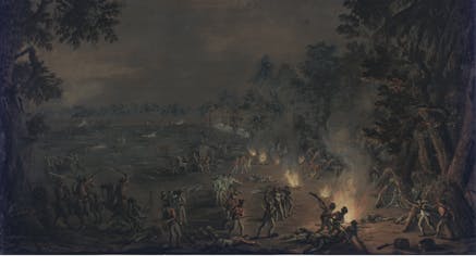
Picturing Washington's Army: West Point | Headquarters
Take a closer look at the buildings and parade ground at West Point. Cadets at the United States Military Academy continue to train on the same ground where the Continental Army encamped during the Revolutionary War.
Image courtesy of Library of Congress, Prints and Photographs Division, Washington, D.C.
Season of Independence: Rhode Island Act Repealing Allegiance to Great Britain, May 4, 1776
Via this act, Rhode Island’s General Assembly formally rejected King George III and broke their legal ties to him months before independence was officially declared by the Second Continental Congress. This document repealed an earlier act passed by Rhode Island’s assembly entitled “An Act for the more effectual securing to His Majesty the Allegiance of his Subjects in this His Colony and Dominion of Rhode Island and Providence Plantations” which had once bound them to Great Britain. In addition to renouncing the King, this document also includes several new oaths created for government officials that removed language that bound them to royal authority.
Courtesy of the Rhode Island State Archives
Finding Freedom: London - Portrait of General Sir Henry Clinton
In 1779, British General Sir Henry Clinton’s Philipsburg Proclamation offered protection to any enslaved people owned by American rebels who fled to the British lines in search of freedom. This was broader than Virginia Royal Governor Lord Dunmore's 1775 proclamation, which only applied to enslaved men who joined the British forces to fight for the King.
The Society of the Cincinnati, Washington, D.C.
Finding Freedom: London - Portrait of Brigadier General Benedict Arnold
London served as a trumpeter in the American Legion, a Loyalist force formed by British Brigadier General Benedict Arnold. This portrait by an unknown artist shows Arnold in his British Army uniform. In the fall of 1780, just a few months before London joined the American Legion, Benedict Arnold infamously defected from the Continental Army and joined the British.
Courtesy of Clive Hammond

"Meet Richard St. George" Performance
Picturing Washington's Army: Map of Verplanck’s Point | Washington’s Tent
As surveyor general of the Continental Army, Simeon De Witt created this map of the encampment at Verplanck’s Point in 1782. The labeled regiments, indicated by their state abbreviations, helped identify the tents depicted in Pierre Charles L’Enfant’s panoramic painting. Washington’s headquarters and the adjutant general’s tent (where L’Enfant stood to paint the panorama) are visible on this map. At the encampment, Thomas Foster, a sergeant in the 7th Massachusetts Regiment, wrote in his journal, “We have here a fine encampment which will furnish the public with a curious map someday or other.”
Image courtesy of Houghton Library, Harvard University, MS Sparks 158.1 (3) Seq. 9
Picturing Washington's Army: Map of Verplanck’s Point | Parade Ground
As surveyor general of the Continental Army, Simeon De Witt created this map of the encampment at Verplanck’s Point in 1782. The labeled regiments, indicated by their state abbreviations, helped identify the tents depicted in Pierre Charles L’Enfant’s panoramic painting. Washington’s headquarters and the adjutant general’s tent (where L’Enfant stood to paint the panorama) are visible on this map. At the encampment, Thomas Foster, a sergeant in the 7th Massachusetts Regiment, wrote in his journal, “We have here a fine encampment which will furnish the public with a curious map someday or other.”
Image courtesy of Houghton Library, Harvard University, MS Sparks 158.1 (3) Seq. 9